
You may have heard on social media or heard on the news about el nino and la nina, but did you know that there are other large scale patterns in the Northern Hemisphere that work just like they do to influence our weather? We call these patterns teleconnections because they can affect meteorological phenomenon long distances away from where they actually occur! Today we will be covering our two favorite teleconnecti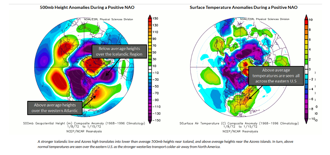 ons for the winter season: the North Atlantic Oscillation (NAO) and the Arctic Osciallation (AO).
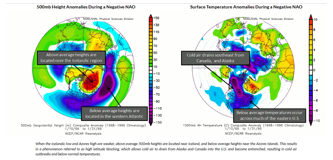
The NAO is caused due to pressure differences between two centers located in the North Atlantic Ocean: A Low Pressure center near Icland and a High Pressure center over the Azores. The two images on the left show the main phases of the NAO, the positive phase and the negative phase. Each of these phases plays a different role in the weather across the Northern Hemisphere, but we will be focusing on our region in the Northeast U.S. for our discussion.
To start, the NAO occurs throughout the year and is split into two defining time periods: The Summer NAO and the winter NAO. The Summer NAO (SNAO) is coming into the spotlight recently with more research focusing on its effects on North American and European Climate as there has not been much long-standing research done on it. The SNAO is much weaker than the winter NAO, but it still plays a role (albeit to a lesser extent) in the climate for the Northeast U.S. during the summer months.
The winter NAO is a major driver for our weather during the winter months depending on the phase. During a positive NAO, we tend to see warmer conditions over the Northeast due to mid level ridging (higher heights over the Northeast driving warmer air to the North) as well as the location of the Jet Stream having a jet streak that tends to be slightly to the East of the Northeast. The position of the Jet Stream during this phase can fluctuate slightly east or west, but this setup is not conducive for our winter storms. The High and Low Pressure centers create such a strong gradient that the cold air that typically flows down from Canada instead gets pushed out of the North American continent before it can settle into the region. This pattern is where we typically see our Inside Track low pressure systems that bring us mostly rain. The negative phase of the NAO is where we see our cold weather and stormier periods featuring our bigger snowstorms. The jet stream during this phase tends to dip further south and can interact with moisture from the gulf of Mexico. Combine this with the cold air that we have in place over the Northeast and you have a recipe for a snowstorm.
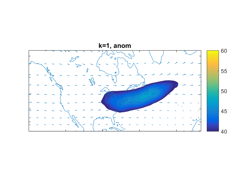
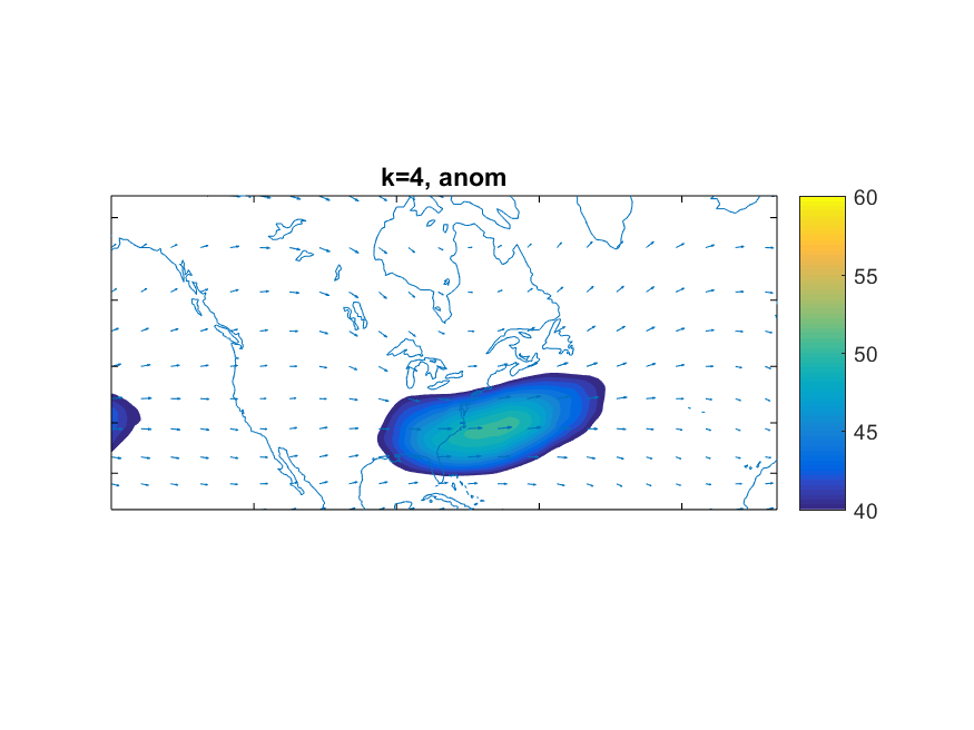
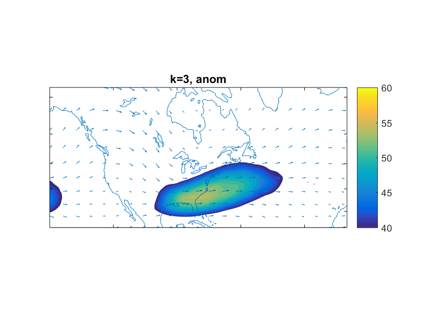
The images above show the jet stream (shaded) during the different winter NAO phases. k=1 shows the jet stream during a positive NAO event (note it is further north and does not interact with the Gulf of Mexico). k=3 and k=4 show the jet stream during negative NAO events.
The above images show this difference in three different typical patterns for the Northeast during the winter season (Based on research by Roller et al. 2016 and Coe et al. 2018 (unpublished)). You can see during a Negative NAO event how the jet stream is located further south and interacts with the moisture in the Gulf of Mexico. The Jet stream is positioned just to the east of the Northeast U.S. which allows it to funnel the moisture up to our region where it can interact with the cold air in place and cause our snow storms. This is where the forecast gets tricky as the position of the jet stream relative to the Northeast region determines how close or far away the storm center tracks which determines the rain/snow line.
Looking ahead, we see that the NAO looks to remain positiv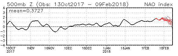 e well into the middle of the month of February. Does this mean that we will have no snow chances? Not exactly, but big snowstorms will be harder to come by and I wouldn’t expect one happening in at least the next couple of weeks.