
“I’m dreaming of a White Christmas. Just like the ones I used to know.”
We all know the lyrics to that famous Christmas carol, but how often do we see a White Christmas in reality?
First we should start by defining what makes a Christmas a White Christmas. By the name, you would assume it means the snow falls on Christmas Day making everything festive and white. However, a White Christmas just means that there is at least a snow depth of 1″ on the ground at any point during Christmas Day.

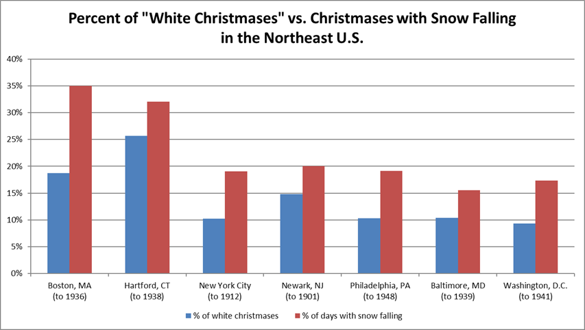
This is actually a lot harder to accomplish than the chance of snowing on Christmas Day with Boston seeing a 35% of chance of snow on Christmas Day compared to only a 18% chance for a White Christmas! Based on this, our chances of seeing a White Christmas are already slim, but this is Boston. If we look further inland our chances increase as we tend to see colder temperatures and a better chance for having had snow fall during the month of December.
Based on Climatology Data, the probability of a White Christmas is least in the Southern States and highest in the Mountainous Regions of the Rockies and northern areas of the U.S. (including Northern New England). Our area tends to see around a 40-60% chance of a White Christmas based on this data. Looking through the records we have for Lowell, we had White Christmas chances both last year and in 2013 based on total snowfall in December before Christmas (11.3″ in 2016 and 18.2″ in 2013). However, both years did feature a warmup the week of Christmas, a trend that has been occurring for the past 5 years in New England (with 2013 seeing a high of 25° on Christmas Day with 40s and 50s the week before, while 2015 saw an unprecedented high of 65° on Christmas Day and highs near 70° the week before!) If this were to continue going forward, that means our chances for a White Christmas could drop further.
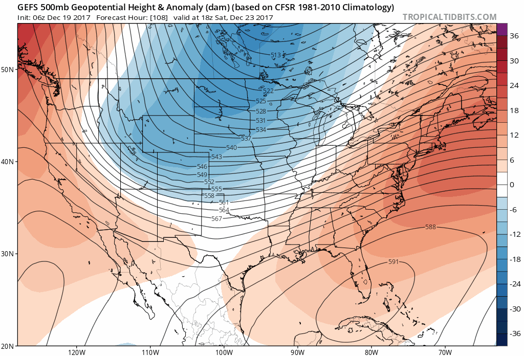 Looking ahead for this year, we still have a good 1-3″ snow pack on the ground (depending on where you are) however, we are seeing a potential for a warmup based on the GFS Ensemble model the end of this week into the weekend as a potential storm moves into New England. Right now both the Arctic Oscillation (AO) and North Atlantic Oscillation (NAO) are positive and are projected to remain positive through Christmas Day. For a good chance of snow in New England, we want both values to be Negative as that means colder air would be in place and storms tend to track off the coast rather than inland (which is likely to happen during a positive NAO and AO). We do see a chance for a cold shot around Christmas Day, but it is too far out to forecast if we will see any snow before then. This warmup could potentially put us just under the threshold for a White Christmas this year, so we will just have to wait and see as the week goes on. Hopefully though we can all say “Let it snow, let it snow, let it snow”