
After a real cold start to the winter season, with nearly 2 weeks of temperatures lucky to make it into the teens, seems strange that we’re talking about a “January Thaw”. The first sign of a pattern change came last week as temperatures hung around the 30’s and 40’s, which could pass as Spring after the previous Arctic Blast. Then, a Clipper Low Pressure system delivered snow to much of Southern New England Wednesday which reminded us that, yes, it is still Winter. But now, forecasters are talking about another January Thaw. So what does that mean?
A January Thaw is essentially what it sounds like. Not uncommon in New England, it is a warming period that can last anywhere from a few days to a few weeks, depending on the big climatic players that control our weather patterns. One of them being La Nina which is noted by the cooling of the equatorial Pacific, which typically has some level of impact on the weather experienced across the United States. On average, a typical La Nina winter pattern delivers the following…

So what does this mean for us in New England? Well, you may of heard forecasters talk last Fall about an expected “milder winter” due to the anticipated strength of La Nina. But how could this be after some of the coldest weather ever recorded in New England’s history? The long blue arrow in the picture above depicts the averaged positioning of the Polar Jet Stream during a La Nina winter. This influences who is experiencing colder/warmer and wetter/drier weather. However, if weather was as clear cut as the picture above, Meteorologists would be out of work. Since the Jet Stream fluctuates, New England’s overall Winter pattern could go either way. The winter season could be mild and dry, cold and snowy, or a combination of the two. Essentially, trying to depict what kind of winter New England will have during a La Nina pattern is a coin flip; it could go either way. Thus, it makes sense that New England could experience a bit of a bipolar winter this year.
Looking at some of the long-range models it appears that temperatures could stay relatively above average throughout the rest of January. Here’s why.
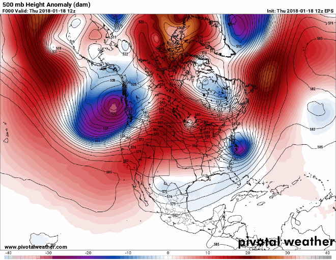
The image above shows a 500mb (pressure level at ~3.5mi above the surface) map which is a great place to find troughs (typically colder and stormier) depicted in blue, and ridges (typically warmer and drier) depicted in red. The European Ensemble Prediction System Model (EPS) indicates that through the rest of January, the jet stream will produce more ridging over New England. The reason being; a strong ridge is expected to set up in the north Pacific (see all the red in the upper left hand corner…that stuff) which, in return, creates a trough over the western US, and ultimately creates ridging over the Eastern US.
How long will this “warming” trend last? That remains to be seen. One thing for sure, February is New England’s coldest and snowiest month. Based on how this winter has preformed thus far, I would say, if you like the cold and snow, the odds are on your side.
-Michael Souza (Class of 13’/14′)