
The first half of February has hardly been like an average winter in New England. The temperatures for Lowell have been all over the place over the course of this winter, however, the average temperature has remained at the average mark or a little below the average mark. The other thing about the current winter is that we are still nearly ten inches below average for snowfall totals. This might be music to one’s ear but a cacophony to another’s! Below is the current snowfall total for Lowell through February 16th, 2018:
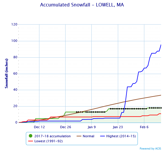
Graph courtesy of National Weather Service NOWData.
The green line with the black shading underneath is the current total for Lowell this winter. As you can see, Lowell has yet to break 20 inches of snow. The blue line represents the terrible winter we had in 2015, where we had over 70 inches of snow in a span of a little over a month. Back in 1992, Lowell saw the least amount of snow, as shown by the red line. The maroon line represents the average snowfall for Lowell.
Back to this winter…
Over the past couple of days, Lowell has seen above average temperatures for this time of year, which in my eyes is O.K. if we’re making up for the negative temperatures we experienced early in January. Within the last 7 days, the temperature has averaged about 40.7 degrees Fahrenheit, which happens to be 2.7 degrees above average for this time of year. And over the next 10 days, the temperature is *forecasted* to average about 47.6 degrees Fahrenheit – nearly ten degrees above average for this time of year! Can you say heat wave?! Time to bust out the swim trunks, bathing suits, and beach towels!
Not just yet. Don’t quit on Mother Nature just yet!
On Saturday night, the city of Lowell can possibly break the 20-inch mark for snowfall. There is a small storm coming that is going to bring snow to the Lowell area. The city should expect to see snow amounts of anywhere between 3-6 inches. Timing for this storm is not going to be bad. The storm will come in between 10:30-11:30pm Saturday night and exit by 6am Sunday morning.
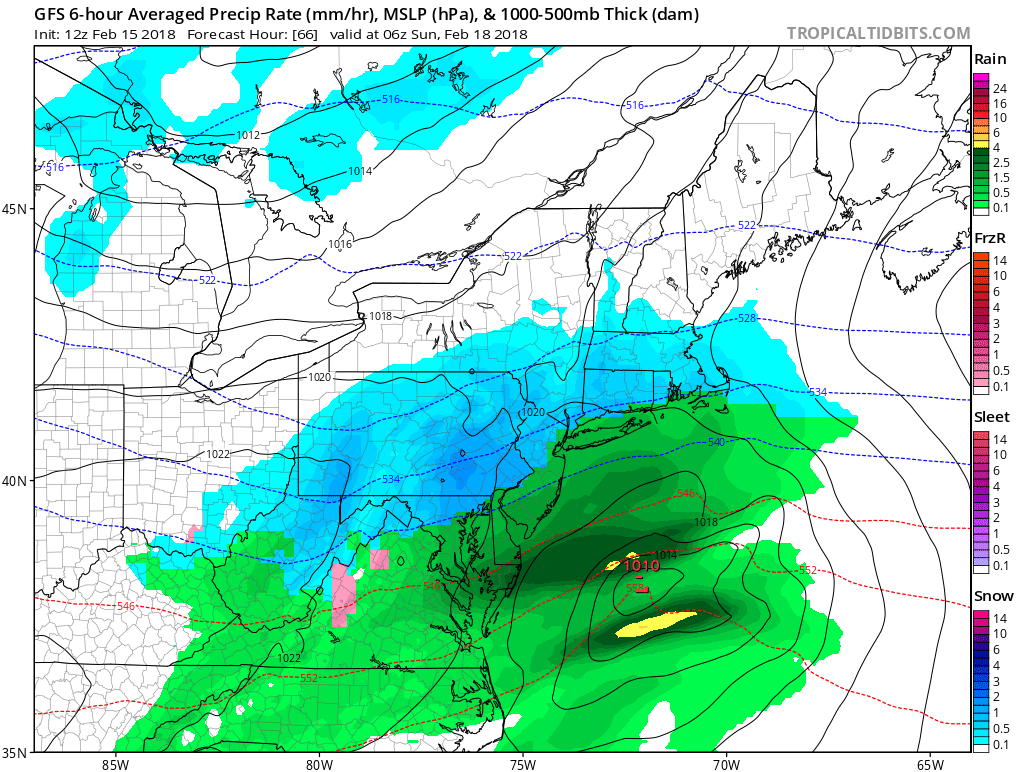
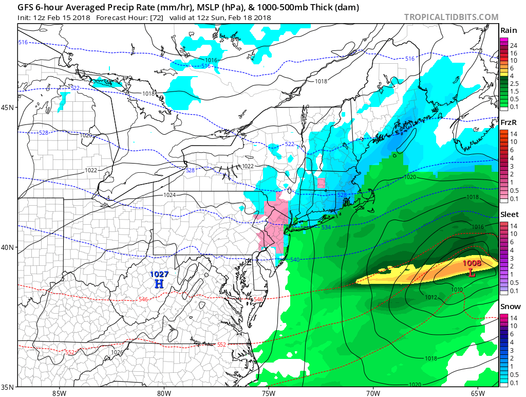
Images courtesy of Tropical Tidbits.
The storm, like I said, will begin to drop snow on Lowell around 10:30. The snow will be flying at 1:00am as seen in the first radar image, and will almost be done by 7:00am as seen in the second radar image. It will be a fast moving storm and the city of Lowell will wake up in the morning with a small blanket of snow!
“Yay, we’re finally getting more snow. I hope it stays around for a while this time!”
Sorry, I can’t say that this snow is going to last past Tuesday. On Sunday, temperatures are going to be in the middle 40’s. Monday will also be in the middle 40’s. However, Tuesday it is forecasted to be in the mid 60’s and rainy, so any snow left over is going to be torched by the warm temperatures and the rainfall.
And when next week’s warm stretch comes to town, please don’t count Mother Nature out just yet. Just when you think spring is upon us, she strikes back with a snowstorm!
Not to be on the gloomy side, but even though we are getting warm temperatures now does not mean that March is going to be a warm month. Typically, the average temperature for March is about 43-46 degrees Fahrenheit. Look at last year. We had temperatures in the 60’s and low 70’s over a span of ten days last February. Then guess who decided to show up again? Winter and Mother Nature. We had below average temperatures for March of 2017 and nearly below average temperatures for April of 2017 as well. We also had a few snow events in March and early April.
Before I make my closing remarks, I would like to advise readers that winter is far from over. March 21st is still over a month away. I don’t mean to be the gloomy guy over here, but I don’t want anyone to be surprised if March surprises us with any late season snow!
I hope everyone enjoyed reading my first blog posting for UMass Lowell! Have a great week everyone, and enjoy the spring-like temperatures next week!