
Finally, frozen New England will have a chance to catch its breath. After a record-setting cold weekend, temperatures will moderate this week. Some light snow will affect the evening commute tonight but then dry weather takes over through Thursday afternoon. Temperatures will surge well above normal by the end of the week as a low-pressure system tracks to our west. Heavy rain and gusty winds will be possible overnight Thursday into Friday and again on Saturday.
Records Set
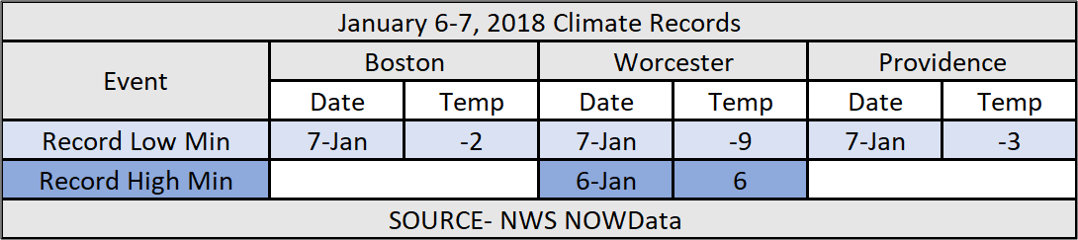
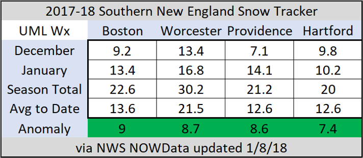
On Sunday morning Boston tied its record low from 1896 while Worcester set its second record low minimum temperature of 2018 (joining New Year’s Day). In 2017, just 3 record low minimum temperatures were set or tied in Boston, Worcester, and Providence. We have already passed that in 2018. Thanks to last week’s winter storm snowfall totals are above average so far this season. These four locations are the official climate sites in Southern New England. They are located at the four airports (Logan, Worcester, TF Green, and Bradley). We may add an inch to these totals this evening.
Short Range
Temperatures will max in the upper 20’s/low 30’s this afternoon with the warmest temperatures in Southeastern MA. A disturbance ahead of a frontal boundary will touch off some light snow showers in time for the evening commute. The air is very dry in Southern New England so a lot of the precipitation will evaporate before it hits the ground. That said, the ground is frozen so even light snows will stick to the roadways making travel slippery between 6-8 PM. 1-2″ may fall at the Cape between 7-9 PM.
High-pressure returns on Tuesday and Wednesday with seasonable temperatures. Max temps will be in the 30’s inland both days while temps near 40 are likely in the coastal plain. Low temperatures Tuesday night into Wednesday will drop into the teens. There will be melting during the day tomorrow which will then re-freeze. If traveling, be aware of black ice.
End of the Week/Weekend
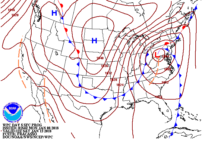
On Wednesday, a storm system will begin to emerge out of the Rockies. This storm will track to the east and the area of high pressure will slide offshore. Winds will shift to the southwest and with it will be a return of mild temperatures.
On Thursday, temperatures should reach the upper 40’s, perhaps low 50’s, across most of Massachusetts, Rhode Island, Connecticut, and Southern New Hampshire. Temperatures will be even warmer on Friday with most of the region in the low to mid-50’s! With the mild temperatures, there is a chance of rain. This far out its tough to pinpoint exactly when the rain will fall but the chances increase overnight Thursday into Friday and continue through Saturday. There are multiple waves of low pressure along this frontal boundary. There looks to be one wave Friday morning and a more significant storm on Saturday. The Weather Prediction Center’s opening guesses on rainfall over the next 7 days is 2-3″ across Southern New England, with the jackpot over SE MA, the Cape, and Islands.
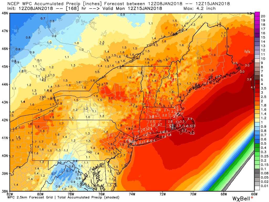
Colder temperatures are possible by Saturday AM north of the MA Pike so the rain could change to a wintry mix by the end of the storm. Its too soon to know so stay tuned. Gusty winds would be a factor on Saturday thanks to the track to our west. The Patriots-Titans game Saturday night will be impacted by the weather. Whether its wind and rain or just wind expect the kicking and passing games to affected. This track is bad news for ski country in Northern New England as even the mountains would be on the warm side of the storm.
After the storm passes, below normal temperatures will return for Sunday and early next week. Whatever hit the mountains take this weekend will be corrected by man-made, or perhaps natural snow by the middle of next week.
-Zack Green (UML Class of 2011)