
A rapidly intensifying storm is expected to pass off the East Coast of New England on Thursday. A combination of heavy snow and high winds will create blizzard conditions in some areas. Coastal Flooding is also considered a risk as strong winds and high astronomical tides come together during the afternoon on Thursday.
Currently, the system is forming down along the Florida coastline and is expected to bring wintry precipitation from Florida up the Eastern Seaboard. Winter Storm Warnings are in effect from the Gulf Coast of Florida up through the Carolinas at this time, with Winter Storm Watches from Virginia up to New England. Additional advisories and warnings will be issued, likely including blizzard warnings for some areas, as the time frame approaches.
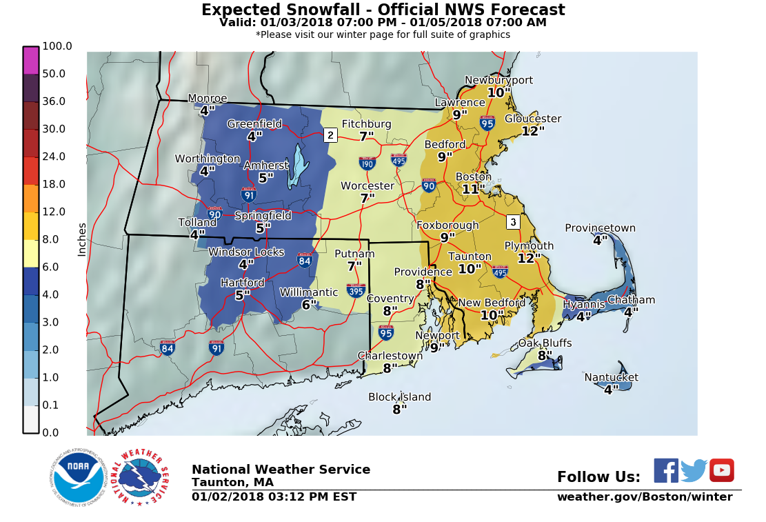
This afternoon’s guidance has trended westward with the system, increasing snowfall totals for many. As the final track of the system comes into better focus, snowfall totals will continue to be refined.
This is the current thinking for snowfall by the National Weather Service. The highest snowfall totals will favor the eastern portion of Massachusetts, with snowfall tapering off the further west you go. Warm air ahead of the system, along with warmer water temperatures, will allow the cape to transition to some mixed precipitation and rain which will create a sharp cutoff for precipitation totals as seen on the map.
Winds from the northeast will gust above 60mph at the height of the storm. These strong winds will cause visibilities to fall as snow already on the ground begins blowing and drifting. The combination of snow and wind could cause power outages in several locations. There will be a major outbreak of artic air behind this system with dangerously cold wind chills. If you do lose power, I would highly recommend that you see shelter somewhere where it will be warm. Anyone heading outside should wear multiple layers and minimize exposed skin as frostbite can develop quickly under such conditions.
Coastal Flooding is also a concern during the high tide on Thursday afternoon. While the strongest winds should pea after the high point of the tide, winds will still be quite strong curing this time period and will help drive the already high tide further onshore. People living in low lying areas along the coast should be prepared for flooded streets. Any water left behind after the tide recedes may also freeze leaving large areas of ice behind.