
Timing:
The storm should arrive late Wednesday night around midnight with the snow quickly becoming heavy. The heaviest bands of snow will occur overnight Wednesday into the early morning hours of Thursday (Between midnight Wednesday and 7 or 8AM Thursday) and then will lighten up throughout the day on Thursday. The storm will exit during the afternoon hours of Thursday.
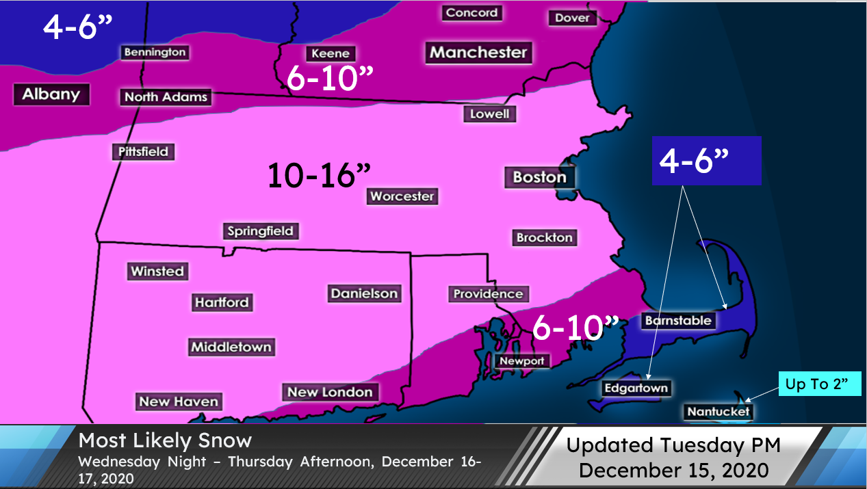
Amounts:
Much of southern New England will receive plowable snow with 6+” likely widespread with the exception of Cape Cod and the Islands. The greatest risk for 1 foot or more of snow will be in southern Worcester County MA, northern and western CT, and northern RI where there could be localized amounts up to 16″. In the immediate Lowell area, around 10″ looks likely, though the amount could go down if the storm takes a more southern track (There’s been a trend in a more northern track so I’m going with 10″ for right now; Stay tuned). Because the storm seems to be taking a more northern track than expected, the area north of the Mass Pike will end up with more snow than previously expected, so I included them in the 10-16″ range. This more northern track however will allow the rain-snow line to affect the southern New England coastline from New London to Cape Cod and the Islands, where rain could mix with the snow during the middle of the storm (More in the uncertainty section).
Uncertainty:
For most areas, there’s not much uncertainty with the amounts since there will be plenty of cold air in place, however there is still some uncertainty in northern and southeastern areas. For northern areas (Including southern NH/VT and the Lowell area), if the storm ended up taking a more southern track, the snowfall amounts will decrease since there will be a sharp cutoff to the precipitation on the northern side of the storm. Today there has been a northward trend with the storm on the models, so the snowfall amounts for Lowell have increased. For southeastern New England, the problem is the rain-snow line. The recent trend to the north will allow the rain-snow line to potentially impact the snow amounts along the southern coastline. How far the rain-snow line moves north will determine exactly how much snow will fall there. What is certain is that the outer Cape and the Islands will receive less snow due to a flip to rain or mix mid storm. For now, it looks like the southern coastline will get 6-10″ with lesser amounts on the Cape and the Islands, which will get 4-6″ (and less than 2″ on Nantucket), since they will be mixing with rain for longer. The snow will also be wetter than northern areas which will cut down on amounts as well. Towards the end of the storm, southeast New England should flip back to snow for a brief period of time.
