
Good morning!
Rain has overspread the region early this morning as forecast. The forecast has become more favorable for higher snowfall amounts; the details are below.
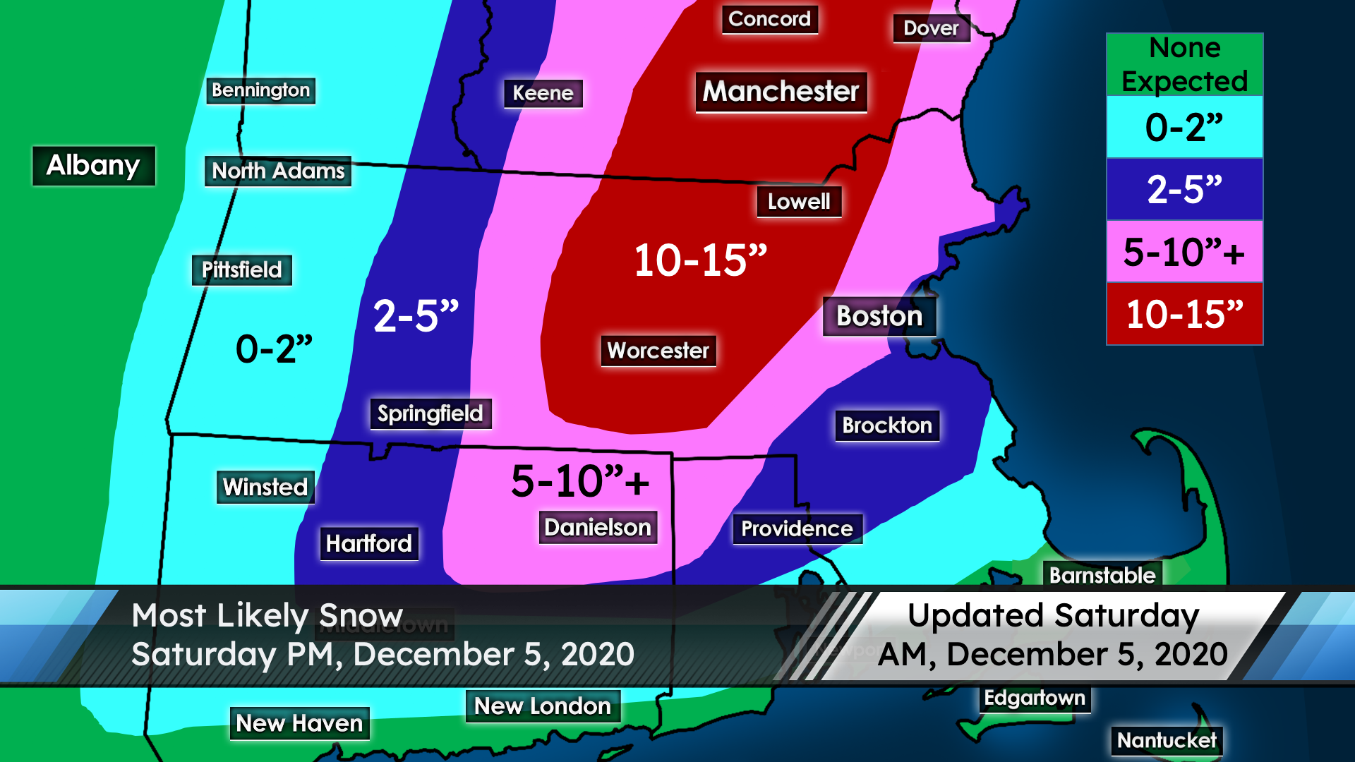
Amounts: Expect a swath of 10-15″ for south central New Hampshire into central and interior northeastern Massachusetts, as the heaviest snow bands should set up around here. I have the Lowell/Dracut area within this range as the interior portions of the Merrimack Valley (including the Lowell to Manchester corridor) should be subject to some of those very heavy snowfall rates. The jackpot will likely be just north of Worcester, though. This 10-15″ range extends off the map into a large area of central New Hampshire and Maine.
Elsewhere, a large swath of 5-10″ surrounds the 10-15″ zone, though some spots in the 5-10″ zone may overperform. This zone includes most of coastal northeastern Massachusetts, Boston and its immediate northern/western suburbs, northeast Connecticut, northwest Rhode Island, and continues northward into much of New Hampshire and Maine. There is some uncertainty at the immediate coastline on amounts, though. I have 2-5″ forecasted for the southern suburbs of Boston, the Providence area, the Connecticut River valley, and the very immediate shoreline from Cape Ann to Boston. Amounts decrease further west and south, where rain will be more prevalent and flooding may even be an issue.
Timing: Rain changes to snow first in the Worcester Hills, later this morning. Other interior areas, including the Lowell/Dracut area, change around midday to early afternoon, with the coast changing to snow during the late afternoon to early evening hours, as temperatures cool to around freezing. The heaviest snow locally falls during the late afternoon to mid evening hours, during which 1-3″ of snow per hour is possible. Snow winds down this evening and ends completely around midnight.
Impacts: Travel will be extremely dangerous with extremely heavy snow this afternoon. When combined with strong wind gusts exceeding 35 mph, periods of blizzard conditions are possible. Additionally, this will primarily be a heavy wet snowfall; the weight of the snow may cause downed tree limbs and wires. Some power outages are likely with the potential for widespread power outages and significant property damage. The snowstorm of March 7-8, 2018 also featured a band of intense heavy wet snow and the result of that storm was huge percentages of people with no power (as an example, 94 percent of Dracut was out in that storm), as well as countless trees, wires, and tree limbs down. I’m not saying we’ll see a similar outcome today, but be prepared for the possibility that we do.
Have a great day!
-UML Student Forecaster Nathan Coram