
Good evening! Quick update on the storm. A bit has changed, so read on.
Hazards: Heavy snow causing travel disruptions. Gusty winds will cause a risk for isolated power outages, as well as likely some periods of blizzard conditions.
Timing: Snow begins in the early morning hours Saturday before sunrise. The heaviest snow will occur from late morning/midday into the evening hours, winding down by late evening and ending completely by midnight.
Amounts: Over the course of the day, one thing has become obvious: we are shifting to a major and potentially blockbuster snowstorm. In fact, this forecast – which I produced collaboratively with other UML meteorology students in the weather lab tonight – may already be too conservative, as the late-evening model runs are going insane.
I would like to see the overnight guidance before committing to any further increase of totals, but here we go: I am forecasting a widespread 15-25″ of snow in eastern MA and southeast NH, with some towns potentially breaking 30″ in the heaviest snow bands. The snow will be generally very light and fluffy, though south of Boston it may get a bit heavier as temperatures will be a bit warmer. (The reduced fluff factor south of Boston is made up for by higher liquid-equivalent precipitation amounts.)
The next 24-36 hours will be critical for honing in on where the bands are likely to set up (more in the uncertainty section). Further to the west, expect a decrease in totals (though even now, it looks like I may need to shift some of the heavier totals to the west; I will wait until the morning to make any further drastic changes).
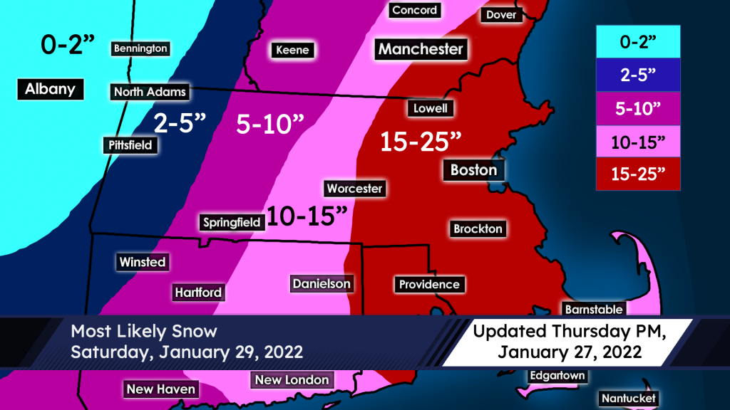
Uncertainty: Well, well, well … the last 12 hours have been something. This evening, the remaining eastern-leaning guidance caved to further west solutions. It’s shaping up to be all-systems-go for a blockbuster storm, potentially of a historic nature. I’m not fully committing yet, but it won’t take much at this point. It seems likely that some towns will rocket past the 25″ ‘maximum’ on the map; the best chance is south of Boston but some guidance is hinting at a secondary maximum north and west of the city. This should hopefully become clearer over the next 24-36 hours. It’s not out of the realm of possibility that some places could see 30-45 inches of snow, as there is some possibility of extreme banding. I’m leaving it off the map for now, in part because the track could still wiggle a bit. Even then, barring a drastic change, I’m very confident we will see over a foot of snow in our area and likely quite a bit more than that. Right now, the bust scenario is just a regular large snowstorm.
Elsewhere on the map, the main question marks are western New England and Cape Cod/the Islands. Starting with western New England, the westward shift puts those areas in play for heavy snow; some guidance is still keeping totals limited out that way. The majority of models have caved toward a heavier solution even in that region, but just to be safe I will wait to make further changes. With regard to Cape Cod and the Islands, they are running the risk of the system coming so far west that it could make the snow very heavy and wet or potentially even mix with rain; this low ratio snow would cut back on totals a bit. The point here is that there’s still some work to be done on the edges, and the forecast will be refined more over the next 24-36 hours.
-Nathan Coram
UML AMS Co-President