Where are you Winter?
This month has been a roller coaster in terms of weather, starting off slightly above average temperature-wise, to a few days worth of winter-like weather and snow, and finally back to well-above average temperatures! Looking at the past few years, this seems par for the course in terms of weather in December: that we are seeing a later transition into winter-like weather from fall-like weather, leading to warmer temperatures and less snow in December. (More on this topic of a shortening of the winter season and delayed transition from the fall season can be read in Coe et al. 2021 (shameless plug) and Allen and Sheridan 2016).
As we approach Christmas and the end of the month of December, there looks to be a pattern change on the horizon, one that could signal the beginning of the winter season in the Northeast U.S.
Understanding the Seasons in Terms of Circulation Patterns

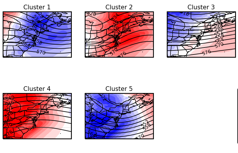
In the Northeast U.S., each season can be broken into distinct daily circulation types that typically occur during it. Above are the typical circulation types for the Autumn season (left, 7 clusters) and the Winter season (right, 5 clusters). These circulation types (clusters) have their own seasonal frequency, some being more likely to occur during the early part of the season (describing the seasonal onset) and others more likely to occur at the end of the season (describing the seasonal withdrawal). For the Fall season, Clusters 3, 4, 5, and 7 describe the end of the fall season and typical circulation types that lead into the winter season and for the Winter season, Clusters 2, 3, and 4 describe the beginning of the season. So by analyzing the frequency of occurrence of these clusters, we can determine what part of the season or what part of the seasonal transition (onset/withdrawal) we are currently in.
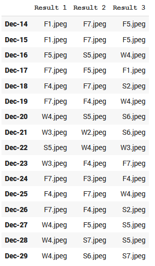
The Magic of Deep Learning
Through the use of deep learning, we can teach a model to match current and forecasted daily circulation patterns to our defined clusters, allowing us to forecast in real-time the current point of the season. The chart to the right shows one such forecast. We compare each day to the Fall (F), Winter (W), and Spring (S,previously not shown) clusters and assign it to the top three clusters. The model has an 85% accuracy when being assigned to just the top cluster, and assigning it to the top 3 clusters increases our accuracy to over 90%. From these results, we can make a prediction for where in the season we are. Anything labelled with an S will not be considered since we are transitioning out of the Fall season. If we take this into account, we can see that the next week we are still predicted to be dominated by Fall season clusters. However, around Christmas-time, we see hints of Winter clusters beginning to become the dominant clusters. This suggests that we are entering the onset of the winter season, this year lining up closely with the Solstice. We can expect to see more wintry like patterns heading into the New Year, but how long will that last? We will have to keep an eye on how the patterns unfold!