
Good evening! Here’s a full update on the upcoming snowstorm.
Amounts
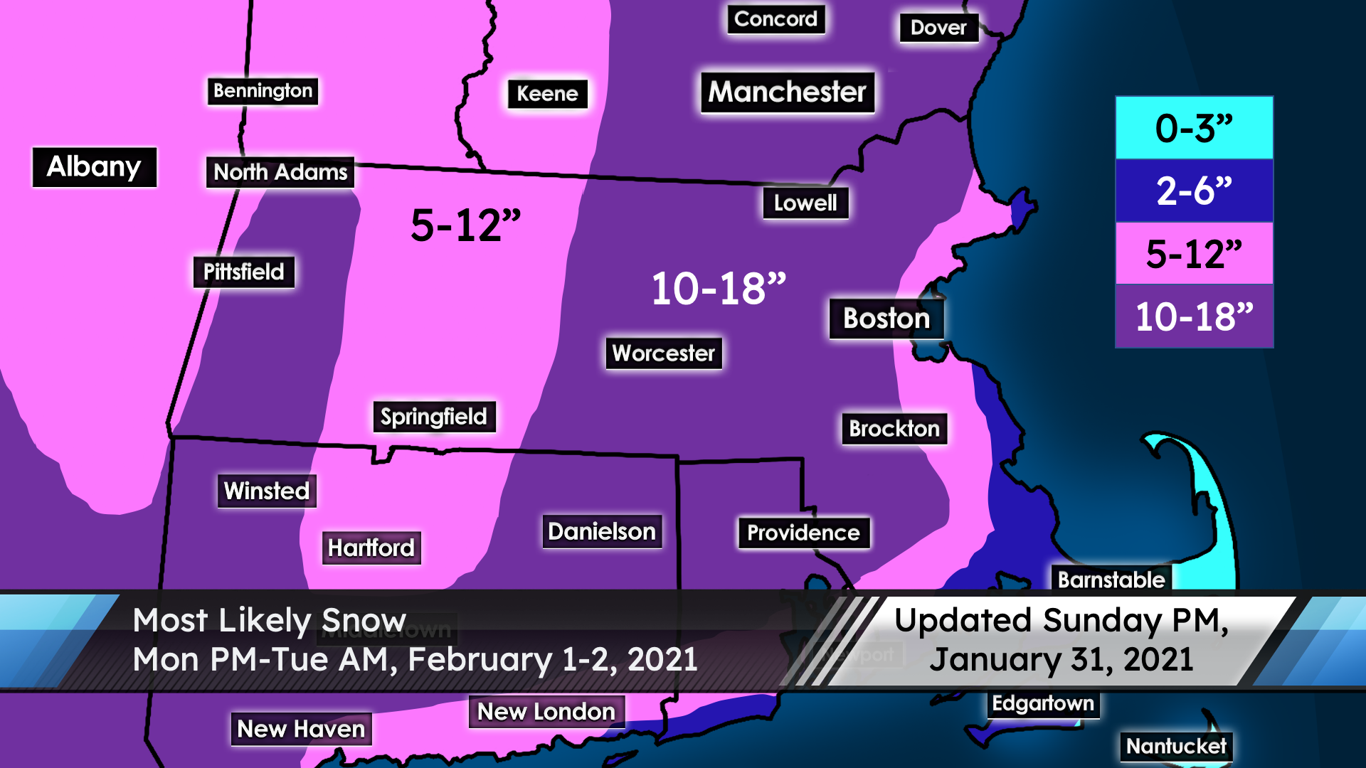
Expect a widespread 10-18″ in much of interior New England, including the Merrimack Valley. There will be a sharp drop-off in totals at the immediate coastline. Most towns near the coast see 5-12″, with 2-6″ at some immediate shoreline towns (and 0-3″ for Cape Cod and the Islands). Also, a little less snow (5-12″) can be expected near the Connecticut River due to subsidence and the effects of being east of the Berkshires.
There is uncertainty at the coast, as well as for Boston’s southern suburbs. Trends today favored more snow, though it’s possible that the forecast could be under-compensating and that Boston could get over a foot of snow. On the flip side, trends could go the other way and favor less snow at the coastline, depending on timing of mixing. Regardless, this is a fairly safe forecast in most locations, including Lowell.
Timing
Once again, the timing shifts earlier. Snow begins midday tomorrow and will be heavy by the late afternoon/early evening. Heavy snow continues into the overnight hours, though gradually winding down. The accumulating snow is likely done by sunrise, though very light snow may continue occasionally during the day Tuesday.
Impact
The snow will be roughly average weight. It won’t be fluffy, but I also don’t expect anything unusually heavy and wet. There is a threat of downed trees and power outages, though, due to strong northeast winds of 10-20 mph, with peak gusts up to 40 mph. Blizzard conditions are possible at times with poor visibility. Driving will be extremely hazardous Monday evening into Tuesday morning, so stay off the roads if possible.
Uncertainty
This is a high-confidence forecast inland; the only major concern locally would be if the dry slot aloft moves in earlier than expected, which would undercut snow totals a little bit. Most of the uncertainty involves amounts closer to the coast. Trends today have favored more snow closer to the coast, but it will be a very delicate situation with the timing of mixing in those areas, so the forecast could bust in either direction at the immediate coastline, as mentioned earlier.
Have a great night!
-Nathan Coram
UML Student Forecaster