Well, we made it. It’s finally spring and winter is in the rearview mirror! Is it just me, or did it feel like it took a long time to get through March?
Since winter recently ended, I feel that it is a good time to review what happened over the course of this winter. Three of the main contributors to this winter were the storms/snow, the odd temperatures, and the Greenland Block. Let’s take a look, shall we?
Let’s get the big one out of the way first – storms and snow.
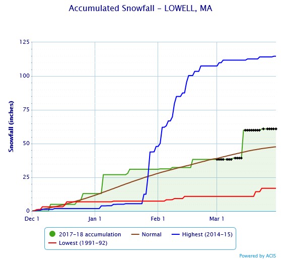
This winter was quite the winter, but only because we received over the average amount of snowfall with only 4 major snowstorms. Lowell saw just over 60 inches of snow this winter, which is approximately 13 inches above the average for the city. Not bad, considering that 3 of the 4 storms occurred in the first two weeks of March – all thanks to our great friend the Greenland Block. We’ll talk more about that later!

Graph courtesy of NOAA NowData.
When I did my evaluation of the winter up until February 15th, the city of Lowell had only seen one significant storm – and that was over a month prior on January 4th! We certainly made up for it in March. It’s safe to say that this winter was in no means a ‘bust.’ While a large chunk of New Englanders do not like the snow, you must admit that a snowstorm in New England makes beautiful scenery.
Underneath the storm category, I must include the terrible windstorm that we had nearly a month ago. On that Friday, March 2nd, we saw blistering winds and pouring rain that made the day worse than it had to be. The city saw over an inch and a half of rain and sustained winds of over 40 mph. Many trees and power lines fell to the Earth as the wind howled throughout the day.
Now, let’s look upon the temperatures of the winter – and these were all over the place!
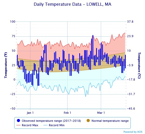
This winter featured record low temperatures and record high temperatures – both an oddity for this time of the year! On the high end of the spectrum, Lowell saw a record high of 75 degrees Fahrenheit on February 21st and an almost record high of 70 degrees on February 20th. On the other side, we had a record low temperature of -9 degrees Fahrenheit on January 7th.

Graph courtesy of NOAA NowData.
As portrayed in the graph, the temperatures were all over the place throughout the course of the winter months. Over the span of the last week in December and the first week and a half of January, temperatures struggled to climb over 25 degrees Fahrenheit, making that time period the coldest part of the winter. After the second week of January, the temperatures rebounded nicely and stayed at or above average for *most* of the remainder of the winter. We did have some slightly lower than average temperatures for a few days in March.
Let’s talk about the Greenland Block, and how it caused 3 storms in 11 days.
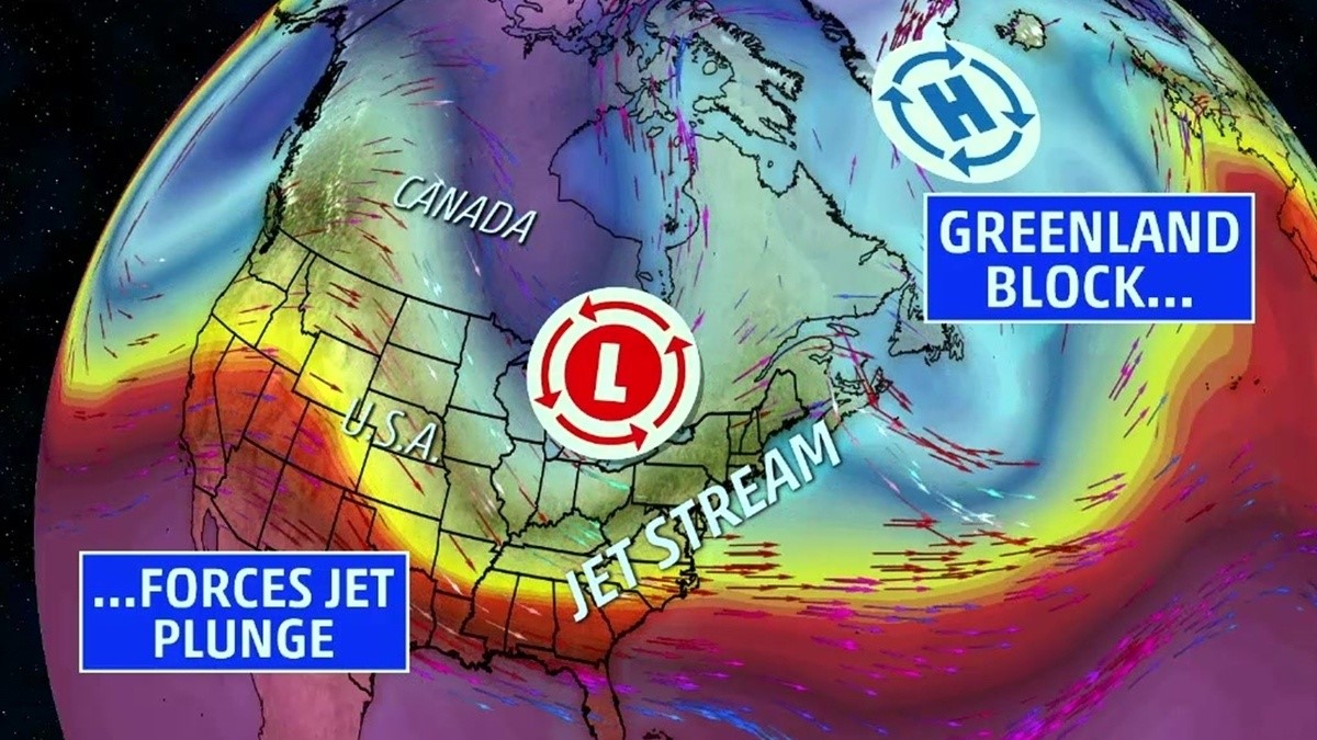
What is the ‘Greenland Block’ you ask? It is a term that is used as a nickname of sorts for the North Atlantic Oscillation, or the NAO. When this occurs, there is usually a high-pressure ridge sitting over Greenland, and a cold air trough that stems from Canada. This trough digs deep into the United States and generally makes the Northeast colder and stormier. Hence why New England was plagued with 3 storms in 11 days.

Image courtesy of weather.com.
This blocking usually creates a stormier pattern for New England. When the storms form, they tend to follow the path of the jet stream – they dive into the lower Mid-Atlantic states and then get stronger as they ride up the Eastern coastline. It was a tough few weeks for New Englanders!
Congrats to New England – we made throughout yet another winter here in this great region of ours. I believe the phrase goes something like, “In like a lion, out like a lamb.” Just remember that we are now in spring, and the temperatures are going to be increasing. Soon, it will be summer, and the days will be long and feature plenty of strong sunshine!
Be sure to follow the UMass Lowell Weather Center on Twitter and like them on Facebook!
